OpenDTM-DE, a free Terrain Model for Germany
Products
- GeoTiff with 1m resolution
- Contours with 10 m interval (shape file)
Background
In Germany, the task of creating terrain models lies with the federal states. This has been solved in very different ways. Fortunately, all federal states now (June 2024) offer freely available high-resolution terrain models (see table 1 below).
A nationwide data set (DGM200) from the Bundesamt für Kartographie und Geodäsie (BKG) exists, but only with a low resolution of 200 metres. The EuroDEM is another low-resolution terrain model with a resolution of 2 arc-seconds (approximately 60 m).
As the BKG will not be creating a high-resolution terrain model for the whole of Germany in the near future (mail 03/2024), this project was initiated.
The first step is to process and intersect the available high-resolution terrain models.
| horizontal reference system | EPSG 25832 |
| vertical reference system | EPSG 7837 - DHHN2016 |
| resolution [m] | 1 |
| tile size [km] | 40 |
Tab. 1: Parameters of the OpenDTM-DE
As part of the implementation of the EU Open Data Directive, geodata is now (June 2024) available as "open data" in all federal states.
| State | Status | Resolution [m] | License | Dataset | Comment |
|---|---|---|---|---|---|
| Baden-Württemberg (Baden-Wuerttemberg) | ✔ | 1 | dl-de/by-2-0 | Link | Download 6-7/2024 |
| Bayern (Bavaria) | ✔ | 1 | CC-BY-4.0 | Link | Download 4/2024 |
| Berlin | ✔ | 1 | dl-de/by-2-0 | Download 10/2024 Source: EPSG:25833 |
|
| Brandenburg | ✔ | 1 | dl-de/by-2-0 | Link WCS | Download 10/2024 Source: EPSG:25833 |
| Bremen | ✔ | 1 | CC-BY-4.0 | Link | Download 10/2024 No-data values are output here as 0. |
| Hamburg | ✔ | 1 | dl-de/by-2-0 | Link | Download 10/2024 No-data values are output here as 0. |
| Hessen (Hesse) | ✔ | 1 | https://hvbg.hessen.de/open-data | Link | Download 6/2024 |
| Mecklenburg-Vorpommern (Mecklenburg-Western Pomerania) | ✔ | 1 | CC-BY-4.0 | Link | Download 10/2024 Source: EPSG:25833 No-data values are output here as 0. |
| Niedersachsen (Lower Saxony) | ✔ | 1 | CC-BY-4.0 | Link | Cloud-Optimized GeoTiff (COG) Download 9/2024 Voids appear in the corners of the tiles. The problem is known and will be fixed. An exact date is not available. The voids have now been filled with gdal_fillnodata. Further information on processing can be found here. |
| Nordrhein-Westfalen (North Rhine-Westphalia) | ✔ | 1 | dl-zero-de ♥ | Link | Download 9/2024 |
| Rheinland-Pfalz (Rhineland-Palatinate) | ✔ | 1 | dl-de/by-2-0 | Link | Download 8/2024 |
| Saarland | ✔ | 1 | dl-de/by-2-0 | Link | WebCoverageService (WCS) original values in centimetres |
| Sachsen (Saxony) | ✔ | 1 | dl-de/by-2-0 | Link | Source: EPSG:25833 Download 5/2024 |
| Sachsen-Anhalt (Saxony-Anhalt) | ✔ | 1 | dl-de/by-2-0 | Link | Download 10/2024 WCS 1.0.0 (!) also available |
| Schleswig-Holstein | ✔ | 1 | CC-BY-4.0 | Link | Download 11-12/2024 |
| Thüringen (Thuringia) | ✔ | 1 | dl-de/by-2-0 | Link | Download 4/2024 The data set from 2014-2019 serves as the basis. Wherever possible, the more recent data set from 2020-2025 was used. The specific coverage at the time of download can be found in these overview. |
Tab. 2: Overview of the existing free terrain models of the federal states with licence, resolution and link. A green tick under Status means that this data set has already been processed. An orange tick means that it is currently being processed.
Unfortunately, the different free licences sometimes lead to incompatibilities. You can read more about this here: Datenlizenzen für Open Government Data - Rechtliches Kurzgutachten (German only). The decision by the state of North Rhine-Westphalia to place the dataset under the "Data licence Germany - Zero - Version 2.0" is very positive. This is the only way to guarantee maximum application possibilities.
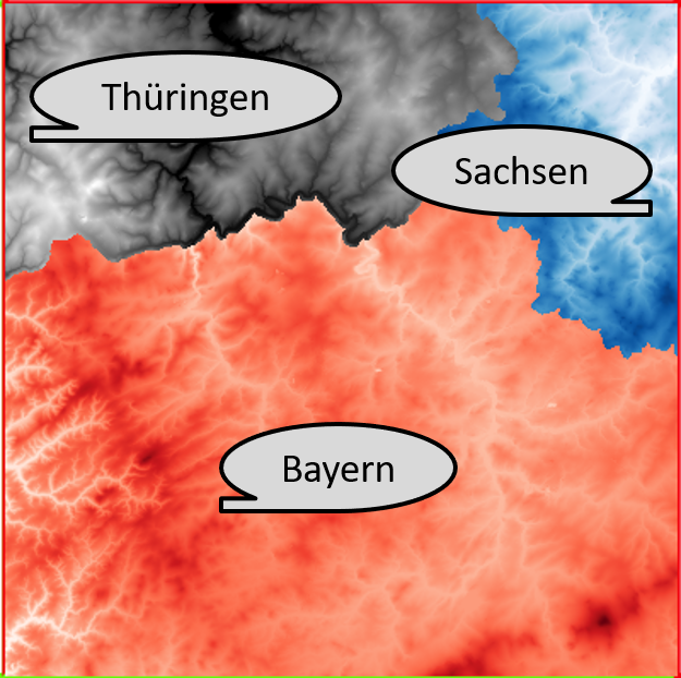
Fig. 1: Example of a coverage imnage
In the event that the data sets overlap, a coverage image is available which shows which layer is on top (see figure above).
Processing of the voids in Lower Saxony dataset
Voids appear in the corners of the tiles. The problem is known and will be fixed. An exact date is not available.

Fig. 2: Example of voids in the dataset
In order to move forward (11/2024), the voids have been filled with gdal_fillnodata.
In order to avoid nonsensical values at the borders, the data sets were clipped with the surface areas of Lower Saxony.
