Open Digital Elevation Model (OpenDEM)
The Portal for sharing the 3rd Dimension

1.9.2017
Open-DEM-Europe - First tiles have been released
With the Infrastructure for Spatial Information in the European Community (INSPIRE), more and more high resolution digital elevation models under free licenses are published.
Unfortunately, the data are mostly only provided with national horizontal and vertical reference systems, and an easy pan-European utilisation is not possible.
The aim is to derive a pan-European digital terrain dataset with a standardised horizontal- and vertical reference system. See here for more information.
Have a look at the OpenDemEurope topic for the Download Webclients.
![]()
9.8.2017
OpenDEM has been restructured and updated.
The historically developed structure has been modified to provide a better overview of the themes. Also, the sites have been updated and broken links checked.
![]()
6.1.2017
BathymetrySearcher map client for free available bathymetry data now online.
Most bathymetry data is the product of scientific work and is unfortunately not available under free licenses in the sense of the Open Knowlege Network.
But all data presented here is at least usable without permission for scientific research, environmental conservation, education or other non-commercial purposes.
Please read the terms of use carefully and properly credit the source!
Only larger marine regions are taken into account.
3.1.2017
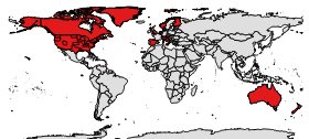
OpenDemSearcher: Now also free middle resolution DEMs available.
Over 60 datasets now covering complete or large parts of north-america, australia and europe.
The digital divide is obvious on the picture on the right (in red covered areas). We hope to bypass the divide by tools for volunteered geographic information in the future.
![]()
1.1.2017
Happy New Year!
2017 is starting with an update of the OpenDemSearcher. More than ten high resolution DEMs have beed added, including parts of Germany, Belgium, New Zealand and Switzerland. North Rhine-Westphalia for example is the most populated federal state in Germany.
Thanks to planlauf for the links!
