Definitions
What is Web 2.0, Crowdsourcing, Volunteered Geographic Information or Free Geographic Information?
The term Web 2.0 describes interactive and collaborative elements of the World Wide Web. Users are creating content like videos, reviews, photos, articles and so on. This type of content is called user-generated content. If a vast project like Wikipedia is based on many many parts of user-generated content components, this is called “Crowdsourcing”. Volunteered Geographic Information (VGI) is a term introduced by Goodchild (2007), describing crowdsourced geoinformation. The most impressive example of VGI is the OpenStreetMap (OSM) project.
One problem is that a large part of the information in the OSM project is not collected by Crowdsourcing. Many datasets are donated by public authorities and commercial companies. Therefore the term “Free” Geographic Information in the sense of the “Free Software Foundation” would be much more adequate. The owner of the geoinformation is sharing his property rights with the public.
Digital Elevation Model, Digital Surface Model, Digital Terrain Model, Digital What ?
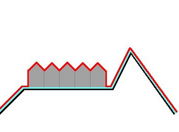
A Digital Surface Model (DSM) represents the earth´s surface and includes all objects on it (Fig. 1 red line). In contrast to a DSM, the Digital Terrain Model (DTM) represents the bare ground surface without any objects like plants and buildings (Fig.1 cyan line).
|
Digital Surface Model (DSM) |
|
Digital Terrain Model (DTM) |
Fig. 1: Represented surfaces by an Digital Surface Model (red line) and Digital Terrain Model (cyan line).
Therefore the DSM elevation is higher in urban and forested areas than the DTM. There is no common definition in scientific literature for the term Digital elevation Model (DEM). Here the most common usage is preferred, which is also used by the most data providers. An overview of the different definitions is given by Li et al (2005) and Wikipedia. The term Digital Elevation Model (DEM) is used here a as the generic term for DSMs and DTMs, only representing height information without any further definition about the surface.
Literature
Goodchild, M.F. (2007). Citizens as sensors: the world of volunteered geography. GeoJournal, 69(4):211-221
Li, Z., Zhu, Q. and Gold, C. (2005): Digital terrain modeling: principles and methodology. pp. 7–9. CRC Press. Boca Raton.
