Open Digital Elevation Model (OpenDEM)
The Portal for sharing the 3rd Dimension
![]()
19.11.2019
Publication UNIBW M: Precise GNSS positioning with commercial smartphones
Very interesting, but be aware that the result was archieved under laboratory like conditions.
![]()
10.11.2019
Gebco Bathymetry Grid 2019 first derived products available
Contour lines and a Raster classification are derived from the GEBCO 2019 dataset.
Download the datasets here. There is also a viewer available.
![]()
27.10.2019
Arc to Meters Online Converter released
Convert arc seconds to meters or meters to arc seconds at a specified latitude.
![]()
25.9.2019
Gebco Bathymetry Grid 2019 released
The GEBCO 2019 Grid is released under "Public Domain" like conditions with attributation. The resolution doubled with 15 arc-second.
![]()
5.9.2019
Saxonia (Germany) added to the OpenDemSearcher
There is a y axis order problem if you like to add the data e.g. to QGIS as a RASTER dataset. There is a good HowTo to solve that problem: www.kreidefossilien.de.
![]()
16.3.2019
Hong Kong (China), Mecklenburg-West Pomerania (Germany) and the Antarktis added to the OpenDemSearcher
For over 40% of the worlds surface now free DEMs exists.
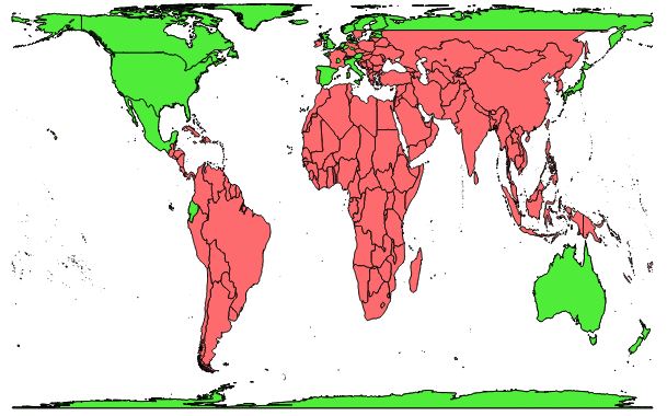
World Coverage of available high and mid resolution DEMs (in green) with Natural Earth country borders.
Map and statistics made with the equal area Gall-Peters Orthographic Projection.
Mind the digital gap!
![]()
10.3.2019
ArcticDEM added to the OpenDemSearcher
The ArcticDEM is a Digital Surface Model (DSM) of the Arctic region covering all land area north of 60°N with 2 m resolution. Be aware that there are some void strips in the dataset (see pictures below). DSM means that the surface is maped with buildings, vegetation and ice cover(!).
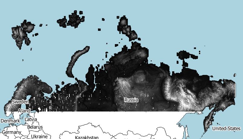
ArcticDEM Coverage Eurasia Release 7: ArcticDEM 1km raster over Natural Earth countries.
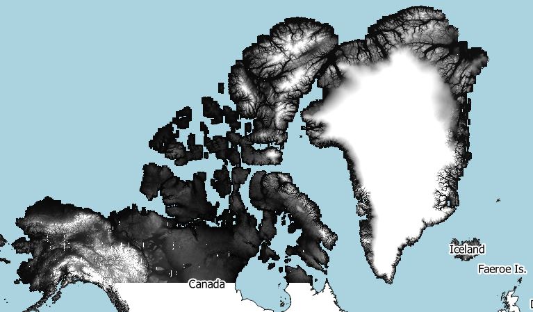
ArcticDEM Coverage North-America Release 7: ArcticDEM 1km raster over Natural Earth countries.
DEMs provided by the Polar Geospatial Center under NSF-OPP awards 1043681, 1559691, and 1542736.
Please read the acknowledgement policy of the Polar Geospatial Center (PGC) carefully.
![]()
8.3.2019
Regions in france added to the OpenDemSearcher
Free DEMs available for the department Calais, the region Brittany and the region Auvergne-Rône-Alpes.
![]()
7.3.2019
Five countrys added to the OpenDemSearcher
Free DEMs available for Japan, Estonia, Scotland, Latvia and Iceland.
