News Archiv 2012

Finally it is done! The OpenStreetMap database is available under the Open Database License (ODbL). The (ODbL) will replace the old CC-BY-SA license.
There is definitely more freedom for produced works (anything other than a database) with the new license. The produced work (e.g. a map tile) could be under a different license than the OdBL. When you use the OSM data with other data to derive a new enhanced database, this database must be under the OdBL.
The SRTM processing on this site is a good example. Because the SRTM data was filtered by OSM data the database (in this case the GeoTiff) must be under the OdBL. A produced work like a map in a PNG format could be e.g. under the CC-BY-SA license. To be compatible with OSM all data on this site is under the OdBL.
25.6.2012
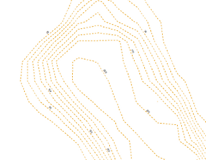
Global ready to use Contour Shape Files available for download now.
The interval of the contours lines is 25m. The world was split in 1*1� tiles.
Different data sources have been used to create a global coverage. The main dataset is the SRTM dataset.
The data is under the current OSM CC-BY-SA 2.0 license and will be later published under the new OSM Open Database License (ODbL).
Have a look at Technology --> SRTM Contours for further information.

2.1.2012
Happy New Year! Time for a �look back at 2011. Elevation data is special, in acquisition, processing and use cases. As expected there was only little input from the community. Nevertheless 3D data will play an important role in future GIS approaches. �In 2012 the focus of the OpenDEM project will be on the creation of HOWTOs for the acquisition of height data with GPS altimeters and GPS augmentation approaches. �A new hardware section will be available were you can lend the desired stuff for height data acquisition. As in 2011 another focus will be the support of a processing chain for the crowed sourced bathymetry data of the OpenSeaMap project.
