Open Digital Elevation Model (OpenDEM)
The Portal for sharing the 3rd Dimension
![]()
13.11.2021
Gebco Bathymetry Grid 2021 Polygon Layer clipped by OSM water polygons
Polygons were derived from the GEBCO 2021 dataset and clipped by OpenStreetMap water polygons (date: 14.07.2021)
The data was split in 32 parts for processing reasons.
Download the datasets here.

4.11.20201
FastAI4DEM
I played around a bit with the great deep learning library FastAI, but unfortunately didn't get convincing results. But try it yourself, here are some templates on GitHub: FastAI4DEM.
![]()
28.08.2021
Gebco Bathymetry Grid 2021 Polygon Layer derived
Polygons were derived from the GEBCO 2021 dataset and clipped by Natural Earth Ocean layer.
Download the datasets here.
![]()
10.08.2021
Gebco Bathymetry Grid 2021 first derived products available
Contour lines and a Raster classification were derived from the GEBCO 2021 dataset.
Download the datasets here. There is also a viewer available.
24.6.2021
Super-resulution with simple mathematics: Directional Convolution Interpolation.
Very promising results with an edge-directed image-zooming method.
![]()
5.3.2021
Argentina added to the OpenDemSearcher.
30 m Digital Surface Model (DSM) as Erdas Imagine Images (.img). These images could be read with common FOSS GIS Software like QGIS.
Partly higher resolution DTMs and DSMs are available (5 m and 0.5 m), marked in dark green in the image below.
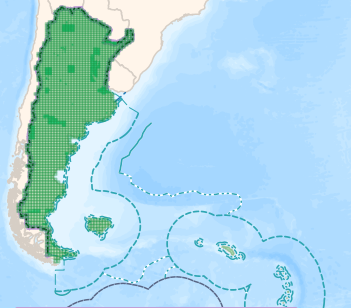
© Instituto Geográfico Nacional & OpenStreetMap
Be aware that the terms & conditions include a none commercial passage.
![]()
3.3.2021
Switzerland added to the OpenDemSearcher.
DTM and DSM available with 0.5 m resolution as GeoTiff and ASCII X,Y,Z files.
The DSM data must be ordered.
19.1.2021
VDSR with upscale factor 5 processed.
As expected the overall error is much bigger and the improvement is not as good as for the upscale 3 model.
19.1.2021
Tuning the machine learning hyperparameters with Keras Tuner results in an improved Super-resolution model.

![]()
5.1.2021
Some new countrys and states are added to the OpenDemSearcher.
France added, including the overseas regions French Guiana, Guadeloupe, Martinique, Mayotte, and Réunion.
Saxony-Anhalt (Germany) added, which completes the five new federal states in Germany.
![]()
1.1.2021
Happy new year!
Some new countrys and states (e.g. Slovakia and Poland) are added to the OpenDemSearcher.
Thanks to Rouven from planlaufterrain.com for the hint.
The deadline for the EU countries for INSPIRE ANNEX 2 was in october 2020. ANNEX 2 includes DEMs. The INSPIRE Data Specification on Elevation–Technical Guidelines defined that the EVRF2007 realization of EVRS should be adopted as height vertical reference for pan-European geo-information. The actual realization of EVRF is 2019. As far as I know Poland is the first country that realized that requirement for there free DTM.
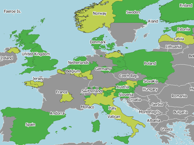
Countries in Europe with free available DEMs. High resolution DEMs (<= 2m) in green, and mid resolution DEMs (2-30m ) in lightgreen. Made with natural earth.
